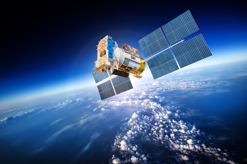
Introduction to Remote Sensing
Remote sensing
Remote sensing is the science (and to some extent, art) of acquiring information about the Earth’s surface without actually being in contact with it. This is done by sensing and recording reflected or emitted energy and processing, analyzing, and applying that information.
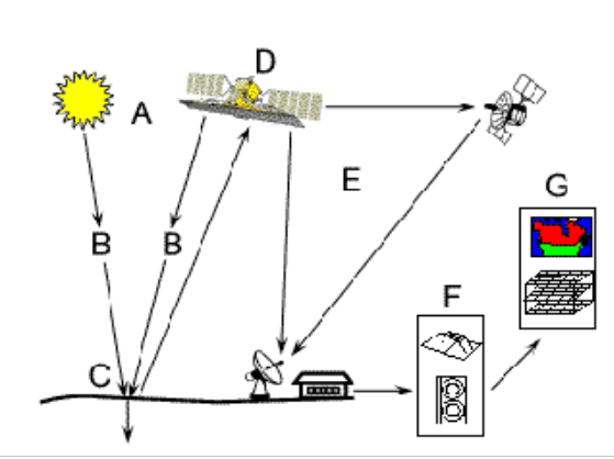
When the energy travels from its source (A) to the target (C), it will come in contact with the atmosphere (B) and then reflect back to hit the satellite (D) through the atmosphere. The satellite has some sensors to record the electromagnetic radiation which is then transmitted to the processing station (E) and is processed into an image. Thus the created image can be interpreted and analysed at (F) to extract information about the target which was illuminated. And ultimately applied to better understand it, reveal some new information, or assist in solving a particular problem.
Electromagnetic Radiation and Spectrum
Electromagnetic radiation consists of an electrical field (E) and magnetic field (M). E varies in magnitude perpendicular to the direction in which the radiation travels and M at right angles to the electrical field as shown in figure below.
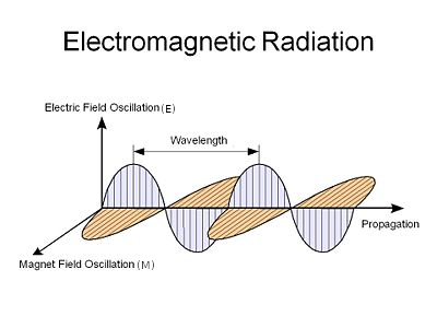
Image source: depts.washington.edu
In remote sensing wavelength and frequency are of major concern. Understanding the characteristics of electromagnetic radiation in terms of their wavelength and frequency is crucial to understanding the information to be extracted from remote sensing data. Wavelength ( $\lambda$ ) is the length of one wave cycle (distance between successive wave crests). Frequency is the number of cycles of wave passing a fixed point per unit time. The relation between wavelength and frequency is:
$c$ = $\lambda$ * $v$
where, $\lambda$ = wavelength ($m$), $v$ = frequency ($Hz$), and $c$ = speed of light
Interaction with the atmosphere
The radiation before hitting the earth and then reflecting has to travel through the atmosphere which has gas and particles. These cause scattering and absorption.
Scattering occurs when electromagnetic radiation is redirected from its original path by the particles or large gas molecules in the atmosphere. Basically, there are three types of scattering:
Rayleigh scattering: occurs when particles are very small compared to the wavelength of the radiation. This causes shorter wavelengths of energy to be scattered much more than longer wavelengths. In fact, the sky appears “blue” during the day due to this as blue (shorter wavelength) scattered more than any other.
Mie scattering: occurs when the particles are just about the size as the wavelength of the radiation.
Nonselective scattering: occurs when particles are larger than the wavelength of the radiation.
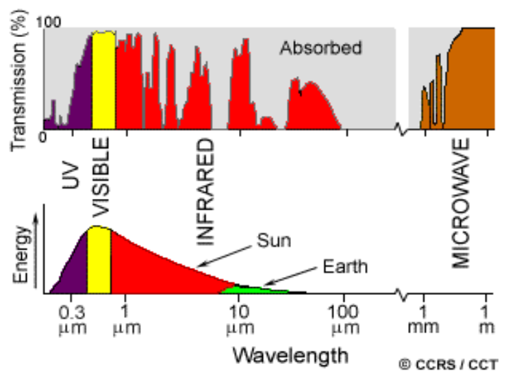
Absorption is the other main mechanism that occurs when electromagnetic radiation interacts with the atmosphere. Ozone, carbon dioxide, and water vapour are the three main atmospheric constituents which absorb radiation. As these gases absorb energy in very specific regions of the spectrum, those areas that are not influenced by this absorption, which are useful in remote sensing, are called atmospheric windows.
Radiation - Target Interaction
Radiation that is not absorbed or scattered in the atmosphere interacts with the target object. It can be: absorption, transmission and reflection. Absorption occurs when radiation is absorbed into the target while transmission occurs when radiation passes through a target. Reflection occurs when radiation “bounces” off the target and is redirected. In remote sensing, we are most interested in measuring the radiation reflected from targets.
Some examples are: Vegetation: Chlorophyll strongly absorbs radiation in the red and blue wavelength but reflects green wavelengths. Also the healthy leaves act as excellent diffuse reflectors of near-infrared wavelengths which can be used to classify the vegetation as healthy or not.
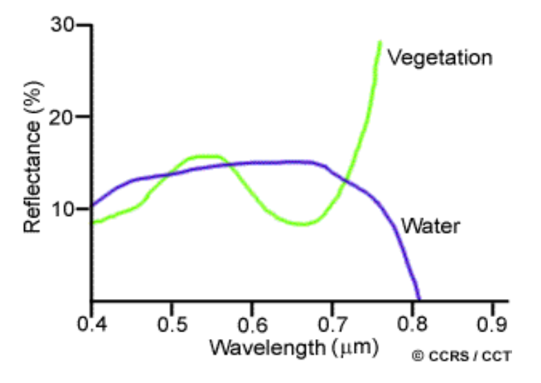
As we can see in the figure, water and vegetation reflect somewhat similar visible wavelengths but are almost separable in the infrared region.
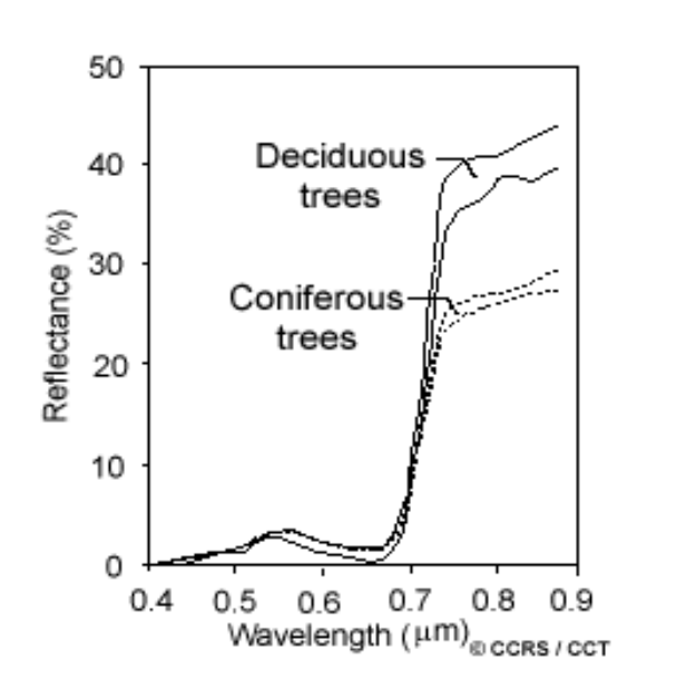
Similarly if we want to distinguish deciduous and coniferous trees, we would go for the near-IR region as they are separable in that region.
Bands
Like our eyes see colors and detect them, remote sensors gather and store information from a narrow wavelength range, called channels (sometimes band).
Hyperspectral bands contain more than 100 bands while multispectral bands have less than 16 bands.
Panchromatic images Panchromatic images are created by combining RGB bands and sometimes infrared channels as well resulting in single band images. Panchromatic images have lower spatial resolution which can be improved by combining with multispectral images. The resulting image is called pansharpened.
Satellites and Sensors
Spatial Resolution
Spatial Resolution is the area in the ground which is represented by a single pixel in an image. SR of passive sensors depends on Instantaneous Field of View (IFOV), which determines the area on the earth’s surface seen from a given altitude at a given point in time. The total size thus obtained by multiplying IFOV and distance from the ground is called resolution cell. This determines the maximum spatial resolution of a cell.
Spectral Resolution
Spectral resolution describes the ability of the sensor to define fine wavelength intervals. Spectral resolution of hyperspectral band, multispectral is greater than pan sharpened. Broadband is better in some cases than the narrowband because narrow bands are susceptible to signal to noise ratio (SNR). For mine extraction, narrowband is more suitable since each metal reflects EM waves of different wavelengths in the given range only.
Radiometric Resolution
Radiometric Resolution is similar to the number of quantization bits. Higher the radiometric resolution, more accurately the sensor data can be represented in an image with a distinct value. If we use 8-bit quantisation, then we can represent the given pixel using digital value between 0 to 255. Similarly if we use 2-bit quantisation, it would be between 0 to 3. A comparison between these can be seen in the figure below:
Temporal resolution
Temporal resolution is the frequency at which an image of a certain area is being captured. Higher temporal resolution means that area has been scanned frequently. Increasing the temporal resolution will decrease the spatial resolution since we need to cover a large area in a small amount of time. Temporal dataset can be used for ground deformation mapping, modeling of exploitation of resources. In the case of Nepal, a temporal dataset was used to map the ground deformation due to the earthquake of 2015.
Multispectral scanning
A scanning system used for collecting data over different wavelength ranges is multispectral scanning. Remote sensors acquire data using such systems. There are basically two modes of scanning: Across-track scanners and Along-track scanners.
Sources for datasets:
Other topics
Radiation and target Interaction
Different bodies have different wavelengths of reflection. We can use this information to separate bodies based on their wavelength in different bands of image. For example, pure water has no color while water combined with other impurities have higher reflectance. Along with impurities, if the water bodies are shallow and sediments are visible then also we may have color due to sediments. Similarly Algae also absorbs blue wavelengths and reflects green wavelengths. The healthy vegetation contains the chlorophyll which has a different signature of reflection than unhealthy vegetation. This can be used to identify the health of vegetation and using temporal data we can identify the degradation of vegetation in an area over the time. Along with water bodies and vegetation, air pollutants, soil quality, salinity of water, concentration of minerals can be detected with satellite images in different bands.
How can you calculate your position using a classical map?
We can use the two reference points in the real world and calculate the orientation of those points with respect to us using a magnetic compass. Then we can draw similar angled lines in our map. Two reference points are sufficient for our location on the map. Similarly GPS also uses a minimum of 3 satellites to calculate the 2d position while inorder to calculate the 3D location, at least 4 satellites are used. But currently multiple satellites are used to figure out the exact location.
Co-Authors: Shital Adhikari and Anil Kumar Shrestha
Resources:
